


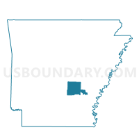
P22 Voting District, Jefferson County, Arkansas
About
Outline

Summary
| Unique Area Identifier | 526856 |
| Name | P22 Voting District |
| County | Jefferson County |
| State | Arkansas |
| Area (square miles) | 0.89 |
| Land Area (square miles) | 0.89 |
| Water Area (square miles) | 0.00 |
| % of Land Area | 100.00 |
| % of Water Area | 0.00 |
| Latitude of the Internal Point | 34.15765700 |
| Longtitude of the Internal Point | -92.06110560 |
Maps


Graphs
Select a template below for downloading or customizing gragh for P22 Voting District, Jefferson County, Arkansas


Neighbors
Neighoring Voting District (by Name) Neighboring Voting District on the Map
- 02 Voting District, Jefferson County, AR
- 36 Voting District, Jefferson County, AR
- 61 (Whiteville) Voting District, Jefferson County, AR
- P317 Voting District, Jefferson County, AR
- P318 Voting District, Jefferson County, AR
- P39 Voting District, Jefferson County, AR
- P41 Voting District, Jefferson County, AR
- P69 Voting District, Jefferson County, AR
Top 10 Neighboring County Subdivision (by Population) Neighboring County Subdivision on the Map
- Vaugine township, Jefferson County, AR (49,211)
- Whiteville township, Jefferson County, AR (2,050)
- Niven township, Jefferson County, AR (1,682)
- Talladega township, Jefferson County, AR (1,267)
Top 10 Neighboring Place (by Population) Neighboring Place on the Map
Top 10 Neighboring Unified School District (by Population) Neighboring Unified School District on the Map
Top 10 Neighboring State Legislative District Lower Chamber (by Population) Neighboring State Legislative District Lower Chamber on the Map
- State House District 18, AR (27,129)
- State House District 16, AR (23,475)
- State House District 17, AR (22,270)